|
April 19, 2013
| By Anne Cheek La Rose
|
Inglewood founder Daniel Freeman had many big plans for his new town. He wanted to grow fruit and nut trees in the wonderful climate found in Southern California. He wanted a lovely area for homes, to be a hub of commerce, and an institution of higher learning to be founded. Mr. Freeman wanted Inglewood to be the center for most everything.
The city’s founder also wanted a school destined to become one of the most well-respected colleges in California and the whole United States.
The year 1880 was when a private college was founded by four religious denominations on what was then wideopen farmland but would become the south end of downtown Los Angeles. It started with an enrollment of 53 students.
At the time there was a boon of university-founding and the University of Southern California was looking to expand. The trustees had a grand vision though the school had opened with just one medium-sized building. Their vision was to build a series of specialized satellite campuses throughout Southern California.
To induce a college to Inglewood, Daniel Free- man offered both land and a monetary inducement. The land was 10 acres for the campus and another 50 lots near- by for housing—all in the area that was to be- come Fairview Heights. So sure was he of the acceptance of his offer that Marlborough Street was readied as the entrance to the campus. If one looks closely at a city map, this is the only truly straight street in the area east of La Brea and north of Florence.
A total endowment of $200,000 was part of the offer and the first contribution was to be $50,000 in cash. USC accepted and the school was to be called Freeman College of Applied Sciences.
The architectural design for the main building was completed. It was similar to the doomed landmark building on the campus of the Massachusetts Institute of Technology. In May 1888, there was a well-publicized groundbreaking ceremony. A cornerstone was laid and excavation for the foundation was begun.
The sagging economy during the winter of 1888 brought the Freeman College construction to a screeching halt. Even with the school construction on hold, USC’s founding president, Judge Joseph P. Widney, offered Freeman an appointment on the Board of Trustees. He declined, but hope for the Freeman campus remained.
Daniel finally gave up the ghost in 1890 and he cancelled the project. He also withdrew his endowment and land offer.
During this attempt at making Inglewood a college town, Grace, the youngest Freeman child and only girl, was a student at USC. She enrolled in 1887 and this could have been the reason for Daniel trying to bring USC to Inglewood.
Daniel Freeman died in 1918. In his will—written in June and just three months before his death— he left a bequest to USC. Over the years, Freeman had many friends associated with the university. The amount of the USC bequest is unknown. However, the estimated value of the estate in 1918 was $1 million, about $15 million in today’s dollars.
|
|
|
|
April 01, 2013
| By Anne Cheek La Rose
|
Knowing the topography of an area explains why the area looks the way it does; in some cases, it explains the paths of streets.
Fairview Heights and part of the industrial neighborhood are the most geologically interesting areas of our city. Inglewood’s northern city limits and the neighborhood of Fairview Heights are part of the last southern slopes of the Baldwin Hills.
East Ellis Ave. is a surprise to most folks when they first come across it. Many people say the street doesn’t look like it belongs in Inglewood. The street is somewhat hid- den, and it is only four blocks long. However, three of those blocks form a mini-canyon.
East Ellis was built in an ancient wash. As late as the last half of the 20th century, Ellis was subject to flooding in heavy rains. The older residents used to tell of having to park on La Brea and wade home. They even told tales of water reaching right up to the front porches in El Nino years.
Beach Avenue—from Centinela to Edgewood—has a steep incline on the south side of the street. This was the natural path for Centinela Creek which flowed from the outcropping of the Centinela Springs in Edward Vincent Park. The springs are artesian wells that have existed under Inglewood since the Pleistocene Era. These springs are the reason Inglewood was founded here: it gave a natural water source in the semi- arid basin for sheep-grazing and growing crops.
Here too—as with East Ellis—the water carved the land. The creek ran west across the park and pooled in what is now the lowest point of Centinela Ave. just before it rises to meet Florence.
There is a tale of the early area before Inglewood was incorporated. It says Beach was so named because folks would boat in from the west and sit on the banks of the widest point of Centinela Creek to picnic and enjoy the day.
In the early days, when only Indians and Mexican land grant owners inhabited this area, the creek ran all the way to Ballona Creek and the wetlands. Centinela Creek’s natural meandering also accounts for the large curve in Beach on the west side of La Brea.
As time marched on and Inglewood grew, changes had to be made. The Centinela Creek bed was covered over and the creek rerouted.
By the way, the portion of the L.A. River—that concrete flood channel we see on the side of the 405 Free- way North at the La Tijera on-ramp—is part of the original path of Centinela Creek when it made its way to Ballona Creek. La Cienega. Do you know what the term means? This lovely Spanish word means “The Swamp.” The name makes perfect sense when you recall the periodic warnings we hear about northbound La Cienega (at Vesta and Industrial) and southbound La Cienega (around the 405 South on-ramp) being flooded during the rainy season.
I have not seen a map of the complete natural Centinela Creek course, but one can extrapolate that these low points on La Cienega are indeed part of the creek’s original path. It’s just east of the flood channel and roughly on a parallel with Beach Ave. where it starts at Centinela.
Streets can be straight as an arrow, like Marlborough, the entrance to the college that never was, or meander when they follow the natural terrain.
|
|
|
|
March 15, 2013
| By Anne Cheek La Rose
|
History is written in many ways. Street names can be fascinating clues to our past.
Some streets are still with us, some are not. Street names that are second nature to us now had very different names in the past.
La Brea was originally Commercial St. and didn’t go north of Plymouth until sometime after 1930. Florence went through a couple of names before it finally settled on Florence. First it was Los Angeles Ave, then Redondo Blvd. (named for the land grant, Sausal Redondo, from which this part of Inglewood was carved). A portion of Redondo is still with us at the fork on Florence. Hyde Park was known first as Capsella Ave. and thereafter as Manor Drive.
The 1906 Sanborn Fire map of the Inglewood Poultry Colony (the area south of Centinela, bounded by La Brea and La Cienega east and west, and stretching south, almost to Florence, shows streets named for the chicken varieties that were raised there. Back then, Beach was Leghorn, Inglewood was Wyandotte, and Glenway was Orpington. Only Plymouth Street remains to remind us of this colorful history.
La Cienega was called Freeman Blvd., but only below Florence and the railroad tracks. The 1921 San- born map shows Centinela
Avenue started at Florence, turned east at its present intersection with La Cienega, and continued to the present intersection with Florence, and formed an arc around the northern portion of the city.
Centinela is a major name in our city: the street, the springs and the former park name. Centinela is the Spanish word for “sentinel.” The name came from the sentinels who watched over sheep herds in the rancho era.
Inglewood has a history of tree and flower street names. Today, we see them mostly in the Arbor Village neighborhood. The Nightshade was the only plant name street to be changed. It became Kelso in 1906. How- ever, the 1912 Sanborn map shows Fushia Drive, Citrus Ave., Laurel St., Dandelion Ave., Guava Ave., and Dalia St. in Fairview Heights. By the way, the Dalia is Inglewood’s official flower.
At one time we had six streets named for women. Stella, now Industrial, was named for Stella Cunning- ham, wife of the tract owner.
Augusta is also in this vicinity. Dorothy no longer exists but used to run behind the old Sears on Manchester. It was incorporated into the Von’s lot when it replaced Sears. Cory Drive, in Centinela Heights, was named for Ruth A. Cory, the 1921 city clerk. Flora Drive is the next street over. Finally Grace Ave., between Locust and Prairie, was named for Grace Freeman Howland, daughter of city founder Daniel Freeman. Howland St., in the same area, was al- so named to commemorate Grace and her husband. Several streets were
named for early mayors and civic leaders: Darby, Dixon, England, Woodworth and Barton. These are located in the Lockhaven area. Interestingly, Warren Lane in Fairview Heights isn’t a “lane” at all. The man’s name was Warren Lane.
And there is the street that leads nowhere: Marlborough Ave., originally College Ave.
In 1888, Daniel Freeman was in negotiations with the new University of Southern California to have their College of Applied Sciences located in Inglewood. Marlborough was to be the entrance to the campus. It never happened and the land that was set aside for the campus became part of the city’s first residential development, Fairview Heights.
It’s Spring, so when you’re planting a garden, include a Dalia or two in honor of our city’s official flower.
Be sure to read more about our streets and the history they reveal will in Part II, in the March 29 edition of Morningside Park Chronicle!.
|
|
|
In Spring of 2000, Inglewood commissioned an historic survey of Market Street. The purpose was to identify individual structures of historical significance and to determine the potential for an historic district project.
Using the National Register of Historic Places Criteria for Evaluation, each structure was looked at with regard to its historic significance locally, regionally and nationally. For structures to qualify, they need to be at least 50 years old, meet at least one National Register Criteria within their historic context and have retained their integrity.
Market Street, La Brea Avenue and Locust Street— from Florence Avenue to Hillcrest Boulevard—was the project area.
One hundred and twelve buildings were surveyed; of these, 47 were deemed to have historic potential. We will concentrate on the eight deemed to have National Register potential.
170 N. La Brea was originally the Citizens Savings Bank, built in . It is notable due to its association with early commercial development in Inglewood. It is now a Chinese restaurant.
320 S. La Brea built in 1948 as Sparkling Cleaners. This is a fine example of Post- War late Moderne style.
3. 330 E Manchester is the Bank of America and a very good example of PWA Moderne built in 1948. The structure next door at 320 was remodeled in 1954 to be part of the bank.
100 N. Market was the Bank of Inglewood built in 1927. It is a beautiful example of Mediterranean Revival style. In 1936 the building was sold to Bank of America National Trust and Savings. For several years it has been a bookstore.
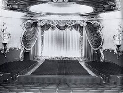
115 N. Market, the Fox Theatre, is the only structure included on the National Register of Historic Places and is the focus of the “Save the FOX” campaign by the Inglewood Historic Preservation Alliance. This fine example of the late Modern style movie theatre was built in 1949 on the site of the Granada Theatre from 1921.
200-204 S. Market is currently Cox Menswear, but was constructed in the Streamline Moderne style so popular in the late 1930s as Scotty’s Men’s Shop.
233-239 S Market, the S H Kress Variety Store built in 1927, is eligible due to its association with the chain store concept of merchandising developed in the 1920s. California was a significant area for Kress. The first store opened in San Diego in 1918 and by 1928, there were 28 stores statewide.
330 E. Queen has been the home of the Chamber of Commerce since construction in 1948. It is a distinctive example of Post-War architecture and one of the finest examples remaining in Inglewood.
I hope you enjoyed this quick tour of the architectural treasures of Market Street and La Brea Avenue. With the coming of the MTA Light Rail, it is hoped that these gems of our early history will be saved and not fall victim to wholesale new development.
|
|
|
 |
|
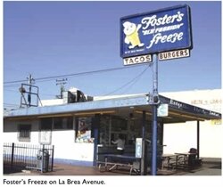
Foster’s Freeze on La Brea Avenue.
|
|
February 08, 2013
| By Anne Cheek La Rose
|
Back in the day, the retail landscape was dotted with the likes of giant coffee cups, big oranges, and hotdogs.
Of course, the most famous was the celebrity studded eatery, the Brown Derby. There were four Brown Derby locations and the last to be demolished was on Wilshire in mid-city. Inglewood is fortunate to have perhaps the most recognizable of LA’s theme architecture – Randy’s Donuts. Randy’s was originally one of 10 such places. There were two size donuts, one large (32 1/5’)—like Randy’s Donuts on Manchester at the 405 freeway— and one somewhat smaller size (23’). Of the five remaining, Randy’s is the best known and certainly the most photographed.
Randy’s has been featured in films, some being Get Shorty, Earth Girls are Easy, the currently running Iron Man 2 and many other movies as well as a number of MTV videos . It is al- so currently seen on TV in the Toyota commercial. Remember when the Shuttle was filmed being pulled by a Toyota truck across Manchester? That’s the one.
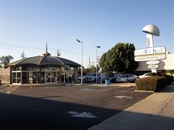
It may not be a theme building per se, but one can’t overlook the Brolly Hut located in Lockhaven. They don’t sell umbrellas, but the structure makes you smile—even if you’re a vegetarian.
Inglewood has another icon. It’s small, very unassuming and most of us drive by daily without noticing. It’s the original Foster’s Freeze on La Brea at 94th St, in the Arbor Village section. It was opened in 1949 and was the first retail location in the state of CA.
Remember Ike and Tina Turner? Their studio was in Fairview Heights. The ad- dress is 1300 N. La Brea, an unimpressive white stucco one-storey structure. But oh—the music that was made there!
Just outside Inglewood, the Beach Boys Monument is on the Hawthorne side of the 105 Freeway. This is the site of the childhood home of Brian, Carl and Dennis Wilson. The Beach Boys were responsible for giving the world the California Sound. To make the pilgrimage, take Prairie south, left on 120th Street, make a left again on Kornblum and go to the end of the street.
Lastly there is the crown jewel of Inglewood, the Centinela Adobe. It is the birthplace of Inglewood and a great place to visit.
I’ll be writing about the about the Adobe in a future edition of Morningside Park Chronicle, so be sure to never miss a single issue!
|
|
|
|
January 10, 2013
| By Anne Cheek La Rose
|
Googie: A structure with tapered columns, exaggerated up-sweeping cantilevered roof, walls of glass to meld inside and outside; using the latest colors and materials with shapes heavily influenced by the space age— reminiscent of space ships and flying saucers; often with a spire piercing the roofline; and usually featuring tropical landscaping. It was utterly bizarre architecture in postwar 1950s. Googie’s Coffee Shop was built in 1949 on the Sunset Strip. The style was known as “Coffee Shop Modern” until the shop appeared in a home magazine. Thereafter, Googie was the term for this wild, futuristic, break-the-sky architecture.
The aerospace industry started here, so it is only natural we have a remarkable number of Googie structures in and adjacent to Ingle- wood. The most intact and regionally famous is immediately outside our northwest city limits: Pann’s. About a mile northeast stands Simply Wholesome, formerly The Wich Stand. The one structure that exemplifies not only Googie but is known the world over for being quintessentially Los Angeles is not far from Inglewood. It is the Theme Restaurant at LAX. This amazing building was conceived and built by a team of engineers and architects that included Paul R. Williams (who is interred at Inglewood Cemetery) and Charles Luckman (who designed the Forum).
In our heyday, Inglewood had four Googie coffee shops, a bowling alley, drugstore, motel, and three car washes. Only two each of the coffee shops and the car washes remain.
The coffee shop that remains intact is Cafetales Restaurant, located on 115 S. La Brea Ave. just north of Manchester Blvd. It’s been through several incarnations since it was constructed in 1958. Sheri’s or Sherry’s was the first name, then Farmer’s Restaurant for a long while. GG’s followed, but closed in 2008. Its paint job has seen better days, but the sign and the interior are intact.
The other coffee shop remaining is Norma’s on 4410 W. Century Blvd., west of Hawthorne Blvd. It started life as a Norm’s, but the exterior has been so altered only the name reminds of its Googie past.
The motel was on Century, next to the 405 North Freeway on-ramp. Thrifty was the drugstore in the Googie style. It was located on Imperial east of Crenshaw. The store was looted, burned, and closed during the 1992 riots, never to reopen. Tropicana Bowl was located on Prairie in the 111th block.
Two of the car washes, Jet on 941 W. Manchester Blvd., and Century on 4700 W. Century Blvd, retain the original Googie signage. The Imperial on 3245 W. Imperial Highway at Lemoli has had all its Googie traces removed.
There is one contemporary example of Googie in Inglewood: the In-N-Out Burger sign on 3411 W Century Blvd. The modern version shows a solid yellow arrow, while the original arrow was made of yellow lights.
The next time you’re out and about, keep an eye open for these wonderfully extravagant examples of our Googie history. They are another example of our history hiding in plain sight.
|
|
|
 |
|
The Fox Theatre auditorium on Market Street in Inglewood in its heyday. Courtesy of AMPAS/The Oscars
|
|
December 10, 2012
| By Anne Cheek La Rose
|
It’s after 2 in the morning; I can’t sleep in anticipation of tomorrow.
I’m in San Diego for the State Historical Resources Commission hearing on the National Register of Historic Places application for the Inglewood Fox Theatre located on Market Street. It’s taken two years to create the detailed and in-depth application and another six months of waiting. Now the day is here.
Nearly four years ago, the Historic Site Preservation Committee (now the nonprofit Inglewood Historic Preservation Alliance) decided to save the Inglewood Fox.
We looked for a project after our restoration of the “History of Transportation” mural. Several possibilities were suggested, but all agreed the Fox was the most endangered structure in town.
Opened in March 1949, the Fox was one of the final structures built by the Fox West Coast chain. Fox studios used the lavish, 1019-seat Fox for first- run movies, previews and premieres. In time, an anti- trust suit separated Fox studios from their movie theatre chain.
The Fox chugged along, but movie theatres became multiplexes and the Fox was no longer viable. Its last gasp was as a Spanish language theatre with the last film shown in 1988. Inside, the Fox is a veritable time capsule–everything remains.
Fast-forward 20 years, when the effort to “Save the Fox” was born. The City of Inglewood made an offer, but the owner did not accept and potential buyers have been few and far between since. With construction of the MTA Crenshaw line on the horizon, the Fox’s asking price has soared out of sight to $1.4 million.
In the hearing room, I listen to the agenda items. There is a video presentation of the seven properties nominated. I hold my breath as one of the properties is pulled from the Consent Calendar; thankfully, it is not the Fox. No further objections and all nominations are passed at 10:07 a.m. We did it!! The Inglewood Fox Theatre is now among California’s Historic Resources and soon, the nation. The Commission will recommend that the National Register approve the nomination.
Now the real work begins. We must raise greater awareness of “Save the Fox” in the community, find a buyer to work with us, raise money and secure grants for the restoration, and obtain the tax credits that accompany historic restoration. There is still a very long road remaining to restore the Inglewood Fox.
|
|
|
 |
|
Brolly Hut, on Crenshaw Boulevard just north of Imperial Highway, is one of the five mid-century buildings in Inglewood identified by the L.A. Conservancy as worthy of being preserved.
|
|
November 03, 2012
| By Anne Cheek La Rose
|
Historic Preservation is a measure of how we value our community. Cities are made of old and new, past and present. If we do not value our past, then we have very little regard for our future. (Read More)
|
|
|
|